|
Farsund & Listalandet
EPostkort / Fotoalbum med over 1200 foto.
Velkommen til Farsund
( Utdrag av Farsund Turistinformasjon brosjyre av 2000 )
Den nåværende Farsund kommune er dannet av de fire tidligere kommunene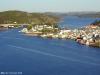 Farsund, Lista, Herad og Spind. Farsund har idag ca. 9.200 innbyggere, hovedsakelig konsentrert om tre større tettsteder; Farsund by, Vanse og Vestbygda. Farsund, Lista, Herad og Spind. Farsund har idag ca. 9.200 innbyggere, hovedsakelig konsentrert om tre større tettsteder; Farsund by, Vanse og Vestbygda.
Sjøfart, fiske og landbruk har vært viktige næringsgrunnlag for befolkningen i kommunen. Fra de eldste tider har folket her
sett mot havet, og tallrike helleristninger viser hvor nært Listalandet har vært knyttet til sjøen. Farsund er idag fylkets største jordbrukskommune med vel 26 km2 produktivt jordbruksareal, 88 km2 skog og 17 km2 ferskvann.
Farsund ble i 1795 erkjent som ladested og kunne i 1995 feire 200-års jubileum. Byen er, slik vi kjenner den idag, skapt av handelshuset Lund.
Jochum Brinch Lund, som må regnes som byens grunnlegger, var på 1700-tallet en betydelig handels- og industriherre.
Vanse var tidligere sentrum i distriktets folkerikeste kommune. Navnet betyr fra gammelt av «Engen ved Vanernes Helligdom», men er siden
blitt forkortet til Vanse. Folketallet er idag på ca. 2.500 innbyggere. Etter sammenslåingen av de 4 kommunene ble det meste av administrasjonen lagt til Farsund, men endel etater ligger fortsatt i Vanse.
Vestbygda er bygget opp rundt den eneste gode havn på den værharde Listakysten. Innenfor de store moloene har fiskebåter sin base og
levering av fisk. Vestbygda har endel særpreget bebyggelse som viser bygdas tilknytning til sjøen og utvandringen til Amerika.
Naturen i Farsund kommune er sterkt varierende, og består av værhard kyst, kraftige fjellpartier, myke sandstrender, og store områder med edellauvskog. Mange kunstnere har funnet inspirasjon i Listalandskapet. I Vanse finner man bl.a. den største samlingen av Mathias 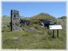 Skeibroks
arbeider. Skeibrok var født og oppvokst på Lista, og var Gustav Vigelands lærer som skulptør. Skeibroks største arbeide er det store gavlfeltet i bronse over inngangsfasaden på Universitetet i Oslo. Skeibroks
arbeider. Skeibrok var født og oppvokst på Lista, og var Gustav Vigelands lærer som skulptør. Skeibroks største arbeide er det store gavlfeltet i bronse over inngangsfasaden på Universitetet i Oslo.
Nåværende næringsliv har endret seg en del fra det opprinnelige næringsgrunnlag. 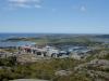 Elkem Aluminium Lista,
rørbehandlingsfabrikken Bredero Price og A-CMI, som fra sommeren -97 starter produksjon av bildeler, utgjør ca. 1300 av kommunens arbeidsplasser. Av industri forøvrig kan nevnes mekanisk verksted, metallstøperi, snekker-bedrifter,
fiskeoppdrett. Elkem Aluminium Lista,
rørbehandlingsfabrikken Bredero Price og A-CMI, som fra sommeren -97 starter produksjon av bildeler, utgjør ca. 1300 av kommunens arbeidsplasser. Av industri forøvrig kan nevnes mekanisk verksted, metallstøperi, snekker-bedrifter,
fiskeoppdrett.
Sjøfart i moderne forstand kom først mot slutten av 1600-tallet, og frem mot århundreskiftet var nærmere 50 fartøyer
hjemmehørende i Farsund. Distriktet sto også for en betydelig del av kaperfarten under krigen 18071814. Utviklingen etter 1814 har gått i
bølger i takt med skiftende konjunkturer. Farsund regnes fremdeles med innen skipsfart, men i de senere år har industrien gått forbi når det gjelder beskjeftigelse.
Lista flyplass ble i 1996 nedlagt som militær lufthavn, men Air Stord har idag ordinære daglige flyvninger fra Lista. Farsund har et godt
utbygget veinett hvor riksvei 43 danner hovedaksen. Den gir forbindelse til E-39 i Lyngdal og til Sørlandsbanen ved Snartemo stasjon. Veiforbindelse er det også til Kvinesdal og Flekkefjord fra Ore og over Åpta.
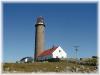 Lista Fyr Lista Fyr
Det 38 m høye landemerket Lista Fyr ligger ytterst på det flate Lista-landet og ble første gang tent 10. november 1836 .
Historien forteller at det i 1850 ble foreslått å erstatte blinkfyret med 3 faste lys for lettere identifisering. Mellom 1851 og 1852
ble det oppført to nye tårn identisk med det første. Ved omlegging i 1873 ble det nordligste av de to nye tårnene beholdt,
mens de to andre ble revet. Det ene ble brukt til å reise Halten fyr, men deler av det andre ble brukt ved reisingen av Svenner og Feistein fyr.
Fire år senere, fikk fyret datidens sterkeste tåkesignal, og på begynnelsen av 1900-tallet ble vekelampene skiftet ut med petroleums glødelamper.
Lista Fyr ble automatisert i 1987 men er fremdeles bemannet. Fyret er et populært reisemål med 60.000 besøkende pr. år, og hvor man
forøvrig finner en meteorologisk og ornitologisk stasjon, samt informasjonssenter. Galleri Lista Fyr bidrar med levende kunstutstillinger og spennende installasjoner. Fyret er helårsåpent.
 Loshavn/Eikvåg Loshavn/Eikvåg
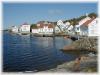
Sør for Farsund finner man Loshavn - en tettbygd idyll med noe av den best bevarte trehusbebyggelse på Sørlandet.
Den vakre uthavnen har sin historie tilbake fra tidlig på 1700-tallet. Under Napoleonskrigen (1807-14) var Loshavn en betydelig
kaperhavn, og utviklet seg kraftig senere på 1800-tallet, ikke minst under de rike sildeårene i 1820- og 30-årene. Den gang var det betydelig trafikk til Loshavn, og man kunne ha opptil 11 loser stasjonert. Loshavn var på denne tiden losstasjon for Farsund. I tillegg til
skole og båtbyggeri var det pensjonat 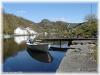 og skjenkestue. og skjenkestue.
Bortsett fra 5-6 fastboende er husene idag benyttet som sommerboliger.
Bakenfor Loshavn ligger Eikvåg, som var en god ankerhavn ved dårlig vær eller islagt sjø.
Eikvåg er første gang nevnt i protokoll fra 1600-tallet, men folketelling ble første foretatt i 1706, da danskekongen ville vite antallet over mulige soldater. Det var da bosatt 9 familier i Eikvåg. Stedet fikk sin første tollstasjon i 1770.
Helleristninger på Penne
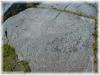 Listalandet er kjent for sine uttallige fornminner, og et av de mest kjente funnstedene er Pennefeltet. 3000 år gamle
helleristninger av skipsfigurer, skålgroper og fotavtrykk vitner om gamle virke- og bosettingsplasser. Man finner også rester
etter gammel hustuft fra folkevandringstiden. Her er gravhauger og gårdsanlegg fra jernalderen, samt steingjerder både fra eldre og nyere tid. Listalandet er kjent for sine uttallige fornminner, og et av de mest kjente funnstedene er Pennefeltet. 3000 år gamle
helleristninger av skipsfigurer, skålgroper og fotavtrykk vitner om gamle virke- og bosettingsplasser. Man finner også rester
etter gammel hustuft fra folkevandringstiden. Her er gravhauger og gårdsanlegg fra jernalderen, samt steingjerder både fra eldre og nyere tid.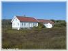
Nedenfor feltet mot vest, ligger de nylig restaurerte gårdsbygningene på Penne, som ble bygd etter lokal byggeskikk med inn-
og uthus sammenhengende i en lengde. Feltet er åpent hele året.
Lista Museum
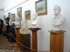 Museet ble opprettet i 1921 av en privat forening som et bygdemuseum for daværende Lista kommune. Museets samlinger
spenner over et meget langt tidsrom - fra eldre steinalder til våre dager. Museet ble opprettet i 1921 av en privat forening som et bygdemuseum for daværende Lista kommune. Museets samlinger
spenner over et meget langt tidsrom - fra eldre steinalder til våre dager.
Lista Museum har en av de største arkeologiske samlinger i Vest-Agder, og består av ca. 2000 gjenstander, vesentlig deponert
av Universitetets oldssaksamling.
Museet eier idag 17 antikvariske bygninger, endel spredt ut over Lista, hvor de ligger bevart i sitt naturlige miljø. Kjernen i samlingen er
Midthasselhuset, et praktfullt skipperhus fra 1742. Museets eldste bygning er stabburet fra tidlig på 1600-tallet. Det finnes likeledes en egen
avdeling for billedhuggeren Mathias Skeibroks arbeider, og er den største Skeibrokamlingen som eksisterer. Museet er sommeråpent.
Husan
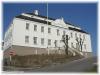 Den gamle ærverdige bygningen er opprinnelig en trebygning fra 1801-1803, bygget av grunnleggeren av Farsund, Jochum
Brinch Lund. Husan ble brukt som residens for hans to sønner, Gabriel og Ebbe Lund. Den gamle ærverdige bygningen er opprinnelig en trebygning fra 1801-1803, bygget av grunnleggeren av Farsund, Jochum
Brinch Lund. Husan ble brukt som residens for hans to sønner, Gabriel og Ebbe Lund.
I 1918 ble Husan gjenoppbygget og utvidet med en ny fløy mot nordvest. Den eldste fløyen ble delvis ødelagt av brann i 1940,
og ble gjenreist i mur og restaurert på slutten av
1950-tallet.
Husan fikk i 1990 Europa Nostra prisen for vellykket restaurering.
Idag er Husan Farsund kommunes administrasjonsbygning med kontorer, kommunestyresal og festsal. I øverste etasje er det en taksal som om
sommeren brukes til utstilling av kunstnere m.m.
Husan er åpen i kontortiden mandag - fredag kl. 08.0015.00.
Møllene på Hervoll
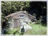 I den lille bekken fra Hervoll til sjøen ved Jølle, har det ligget 15 vannkverner. I den lille bekken fra Hervoll til sjøen ved Jølle, har det ligget 15 vannkverner.
På Hervoll, ikke så langt fra fortidsminnefeltet Penne, finner man to av de gamle kornkvernene. Den ene er bygget av tømmer
fra skipsvrak, og var brukt som bygdemølle helt opp til 1960-årene. Den andre møllen, som ligger noe ovenfor, er bygget av stein.
Møllene er restaurert, og eies og brukes av Lista Museum. Fra R463 går det vei inn til liten parkeringsplass. Møllene ligger i gammelt
landbruksområde med kort avstand til vei og parkering. Mølleplassen er helårsåpen. Se også Museer.
Varnes Fort
Nordvest på Lista ligger Varnes Fort og Varnes Fyr. Herfra kan man se over til Hidra og Andabeløy utenfor Flekkefjord. Stedet er rikt på
historie, med turstier i nydelig natur og utsikt over sjøen.
Batteriet Varnes Fort var underlagt artillerigruppe Vanse sammen med Hidra, Marka, Loshavn og Hausvik. Man hadde 10,5 cm batterier med
16.000 m skuddvidde, og en hastighet på 5 skudd pr. minutt. To av kanonene stod i kasematt med forbindelse opp til kommandotårnet over kanonstillingen.
Batteriet var et ledd i den enorme vestvollen som tyskerne bygde langs hele Atlanterhavskysten. Bare langs den norske vestkysten ble det
bygd ca. 300 batterier. Anlegget på Varnes ble aldri brukt i krigshandlinger. De ca. 100 soldatene som var forlagt til Varnes fikk bare drive øvelsesskyting. Batteriet er helårsåpent.
Vanse Kirke
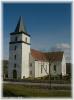 Nær Vanse sentrum ligger den vakre kirken som trolig er blant de eldste og største i landet. Kirken stammer sannsynligvis fra år
1037. Nær Vanse sentrum ligger den vakre kirken som trolig er blant de eldste og største i landet. Kirken stammer sannsynligvis fra år
1037.
I 1848 ble den påbygd til korskirke, og er av kirkemusikere blitt betegnet som en katedral. Vanse kirke ble i 1872 rammet av brann
, men stod i 1875 ferdig restaurert. Altertavlen ble malt i 1866 av G. H. Lammers. Kirken er bygd i stein med kalkpuss, og er med sine 1100 sitteplasser den største i kommunen.
De eldste lysekronene er fra 1569. De øvrige ble gitt til kirken rundt 1903, og stammer fra Slottet i Oslo (kapellet).
I sommersesongen går det bussturer rundt Lista med avgang fra Vanse Kirke. Kirken har flere sommerarrangementer.
Vannsport
Kysten langs Lista innbyr besøkende og fastboende til helt spesielle sjø- og naturoppvelser.
En sommerdag kan vinden stryke mildt over strendene, eller den blåser friskt til glede for dem som verdsetter vannsportens utfordringer.
De unike vindforholdene gjør Listastrendene til et av de mest populære stedene for brettseiling. På Bausjestranden arrangeres Norges cup
hvert år. Bausje har regattakontor, dusj og toalett. Det er imidlertid forbudt med brettseiling visse deler av året av hensyn til fuglelivet.
Farsund har en aktiv seilforening og det arrangeres regelmessige seilaser gjennom året.
Dykkerklubben i Farsund bidro i 1995 til innhenting av funn til Skarvøy-utstillingen. En tur med dykkerklubben til et av de mange vrakene, kan
gi uforglemmelige opplevelser.
I den nydelige skjærgården er det fine forhold for vannskisport.
Turistkontoret gir informasjon om de forskjellige tilbudene.
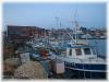
Gjestehavner i Farsund
Farsund gjestehavn ligger like ved hjertet av Farsund by med butikker, banker, postkontor og koselige bakerier, kafeer og restauranter.
Gjestehavnen har 40 / 60 båtplasser med tilgang til vann/strøm, santiæranlegg, bunkers, luftfylling, båt- og dykkerutstyr. En del av øyene i
skjærgården er tilrettelagt med brygge, toalett og grill.
Turistinformasjonen ligger ca. 5060 meter fra havnen.
Lenger vest, innenfor den store moloen på Borhaug, ligger Borshavn. «Molja» er det folkelige navnet på moloanlegget som skjermer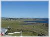 fiskerihavnen mot havet. Havnen har kai, drivstoff, slipp og kort vei til butikker.
Borshavn har dessuten en rik maritim tradisjon gjennom båtbygging, skipshåndverk og fiske.
Skarvøy uthavn
Uthavnene var godt skjermet mot vær og vind, og hadde flere innløp. En av disse havnene var Skarvøy, sannsynligvis brukt som nød- og
transitthavn i flere århundrer. Skriftlige kilder og funn har vist seg å stamme fra perioden 14.18. århundre.
I 1981 ble det funnet rester av et seilfartøy i havnen. Norsk Sjøfartsmuseum foretok, i samarbeid med Farsund Dykkerklubb, utgraving av det
såkalte «Skarvøyvraket». Det avdekket et fartøy ca. 33 meter langt og 7 meter bredt, bygget av grovt materiale. Av
gjenstandene i vraket fant man ut at sannsynlig tid for forliset var mellom 1730 og 1740.
Ca. 3000 gjenstander ble funnet og blant disse var flasker, krittpiper, vinkrukker, gryter, boller og fiskefat, de fleste hollandske. Det ble også funnet en del kinesisk porselen.
Funn i havnen viste en begynnende oppgang med eikeutskipning til Holland på 1700-tallet. Skarvøy avsluttet sin storhetstid med englandstrafikken i 2. halvdel av 1800-tallet.
Skarvøy ble fraflyttet på 1960-tallet.
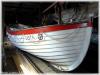
Listerskøyta
Sjøen og fisket har fra uminnelige tider vært en viktig levevei for folket på Lista. Sjøen var også en hovedåre for samkvem mellom
menneskene, både langs kysten og til landene i Europa. Men havneforholdene på vest-Lista var dårlige. Når høststormene satte inn, måtte
båtene trekkes opp av sjøen. Båtene var derfor i den første tiden små og lette, slik at de kunne settes på land.
 I 1890 var moloene i Borshavn ferdige, og båtene kunne heretter ligge på vannet hele året. Følgelig kunne de bygges større. I 1890 var moloene i Borshavn ferdige, og båtene kunne heretter ligge på vannet hele året. Følgelig kunne de bygges større.
I disse årene ble den senere så kjente Listerskøyta skapt. Båttypen gjorde seg bemerket ved fiskeriene både i nord og sør. Ved
en landsregatta i Stavanger i 1868 tok den premier for seilas og sjødyktighet, og godt båtbyggerarbeid. Som følge vokste det opp en omfattende båtbyggervirksomhet på Borhaug.
Frem til 1980-årene var fraktfart på kysten en av de viktige leveveiene for Vestbygda. Da utviklingen gikk i retning av frakt med lastebil, ble
kystfarten redusert. I løpet av en tiårsperiode ble de fleste fartøyene solgt eller kondemnert.
Stiftelsen «Listerskøyta» arbeider idag med å markere tradisjonene omkring båtbygging og skøytetrafikk på Lista.
Østhassel Redningsstasjon
 På Østhassel finner man Norges eneste originale og komplette redningsstasjon fra slutten av 1800-tallet. En modell av stasjonen viser det gamle utstyret som ble brukt; Redningsbåtene "Lista" og "Rauna" På Østhassel finner man Norges eneste originale og komplette redningsstasjon fra slutten av 1800-tallet. En modell av stasjonen viser det gamle utstyret som ble brukt; Redningsbåtene "Lista" og "Rauna"
Utallige skipsforlis langs Listalandet satte sjøfolkenes liv i fare. I 1890-årene ble det bygget molo og havn i Østhasselstrand.
Samtidig ble redningsstasjonen reist her og på rullesteinsøya Rauna.
Rauna er den eneste øy eller holme utenfor det åpne Listalandet, som en del av Listamorenen. Området utenfo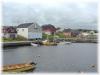 r Lista antas å være Norges
største skipskirkegård. På Rauna ble det bygd et hus til ly mot uværet, hvor de forliste kunne vente på å bli hentet til land. r Lista antas å være Norges
største skipskirkegård. På Rauna ble det bygd et hus til ly mot uværet, hvor de forliste kunne vente på å bli hentet til land.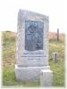
Redningsstasjonen hadde frem til 1972 fast stasjonerte redningsbåter og mannskap. Ved stasjonen er det reist en bauta over livredder Tønnes Samuelsen Kaade, til minne om hans bragder.
Listastrendene
Mange av aktivitetene i Farsund er knyttet til sjø og naturliv. Langs kysten er det godt sportsfiske, og med sine 10 kilometer lange
sandstrender, byr Lista på fine bademuligheter. De myke sanddynene er bevokst med den velkjente marehalmen og strandrug.
På grunn av Listas rike plante- og fugleliv er store deler av strendene vernede områder. Lista har dessuten stor betydning som trekk- og overvintringssted for fugler.
Bausjestranden har toalett og dusj, og er populær blant brettseilere. Den sterke vinden fra nordvest gjør stedet velegnet for godt trente seilere. Brettseiling er imidlertid forbudt om høsten og vinteren.
Lomsesanden er en av de mest populære strendene, med storkiosk tilknyttet campingplassen. Stranden ligger 3 km sørvest for Farsund sentrum. Svabergene på begge sider gir svært gode fiskemuligheter fra land.
Haviksanden, ligger ca. 4 km fra Farsund, og er delt i 3 strandområder. Parkeringsplass og toalett finnes like ved.
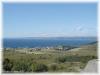
Skjærgården
 Utenfor Farsund ligger den vakre skjærgården, og er et yndet friluftsområde om sommeren. Foruten de opplevelser naturen
selv kan gi, finnes det tilrettelagte brygger, toalett og grill. Et yrende båtliv med gjestebrygger for båtfolket nær butikker, spisesteder og servicefunksjoner, kjennetegner sommeren i Farsund. Utenfor Farsund ligger den vakre skjærgården, og er et yndet friluftsområde om sommeren. Foruten de opplevelser naturen
selv kan gi, finnes det tilrettelagte brygger, toalett og grill. Et yrende båtliv med gjestebrygger for båtfolket nær butikker, spisesteder og servicefunksjoner, kjennetegner sommeren i Farsund.
Fiske: Den tradisjonsrike fiskerinæringen har hatt betydning for Farsund. Idag har man fiskehavn med mottak i Borshavn, og det er etablert oppdrettsanlegg for laks.
Historie: Skjærgården har imidlertid også en annen og eldre historisk bakgrunn. Navnet Farsund kommer av «farten over
sundet», og i 1795 fikk byen rettigheter som ladested. Byen vokste frem på slutten av 1700-tallet og var i mange år godt kjent
som sjøfartsby ute i verden. Etter siste krig var faktisk Farsund den by i verden som hadde største tonnasje pr. innbygger.
Byen ble grunnlagt av forretningsmannen Jochum Brinck Lund. Familien drev en mangfoldig virksomhet, bl.a. innen plantasjedrift i Vest-India
, skipsfart, spinneri, handel og industri. Jochum Lund bodde selv i huset hvor det idag drives bankvirksomhet. De fire trærne i hagen ble senere motivet i Farsunds byvåpen.
Engøy som ligger nærmest Farsund sentrum, vitner om hekseprosessen på 1600-tallet. Historien beretter om tre hekser som ble brent på øya,
hvorav den siste og mest kjente var Barbro Omundsdatter fra Poddeloftet i Herad. Sagnet sier at hun kastet forbannelse over Engøy, slik at
ingen virksomhet skulle lykkes der. Hun ble dømt til døden våren 1667 etter 17 uker i arrest, og prosessen mot henne er bevart i tingboken fra denne tiden. Engøy fikk i 1995 fast forbindelse til Farsund.
Gåsholmen, landstykket mellom Engøy og Farsund havn, hadde tidligere stor aktivitet med kjølhaling av seilskuter og andre reparasjoner. Idag er bl.a. tinghus og forretningslokaler under bygging.
Katland fyr ble tent 1. september 1878, med Abraham Tønnessen fra Loshavn som første stasjonerte fyrvokter. Tønnessen betjente fyret i ca.
12 år. Familien med 6 barn hadde fast guvernante, som om vinteren bodde hos dem på øya. Båtene som familien benyttet, måtte
oppbevares i bunkers på grunn av værforholdene. Fyret ble fraflyttet i 1947, og drives idag ved hjelp av solceller.
Vikholmen ble i 1872 gitt som en gave til Misjonsselskapet av private eiere på Reisvåg. Holmen ble ryddet og dyrket, og fikk navnet
Madagaskar. Hver vår ble det satt poteter, som ble høstet og solgt til inntekt for misjonen. Ved hjelp av innsamling ble det i 1879 reist et
bedehus, som man idag kan se på øya. Det finnes en rekke gravhauger, bl.a. en utgravet kvinnegrav.
Odd Starheim, en ledende person innen motstandsbevegelsen i Sør-Norge, kom til Ullerøy januar 1941. Han padlet inn til øya etter å ha blitt
satt i land fra en engelsk ubåt ved Ystesteinen. På Ullerøy fikk han mat og tørre klær før han dro videre. Starheim ble funnet druknet i Sverige bare 26 år gammel. Ullerøy var bosatt inntil 1960.
Industri: Lundevågen ligger ca. 2 km fra Farsund sentrum og er idag kommunens største sjørelaterte industriområde. Elkem Aluminium 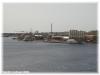 Lista, A-CMI og Bredero Price har tilsammen ca. 1300 ansatte og utgjør Farsunds største arbeidsplasser. Tilsammen ligger det ca. 20 industrivirksomheter ved Lundevågen. Lista, A-CMI og Bredero Price har tilsammen ca. 1300 ansatte og utgjør Farsunds største arbeidsplasser. Tilsammen ligger det ca. 20 industrivirksomheter ved Lundevågen.
Framvaren
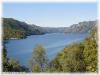 Veien forbi Farsund havnebasseng fører inn til Kjørrefjorden og idylliske Helvik. Kanalen ved Strømmen bro danner passasjen
mellom Helvikfjorden og Framvaren. Veien forbi Farsund havnebasseng fører inn til Kjørrefjorden og idylliske Helvik. Kanalen ved Strømmen bro danner passasjen
mellom Helvikfjorden og Framvaren.
Framvaren er en såkalt terskelfjord, med forhold som er enestående i verdenssammenheng. Under 15 meters dyp er vannet
oksygenfritt, med en konsentrasjon av H2S i bunnvannet som er 20 ganger høyere enn det man finner i Svartehavet. Prosessene som foregår i bunnlagene tilsvarer de samme som i sin tid dannet oljen i Nordsjøen.
I fjordens sydvestre hjørne ligger Listeid naturreservat med en av de flotteste edellauvskoger i fylket. Ved Listeid har man videreført
tradisjonen med båttrekk over til Sigersvold, og man unngår derved den værharde kysten utenfor Lista.
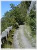 Den gamle veien i Bøensbakkene knyttet tidligere forbindelsen mellom Herad og Lista. Bygdeveien benyttes idag av mange til
fottur eller sykkeltur i grønne omgivelser og har en flott utsikt over fjorden. Den gamle veien i Bøensbakkene knyttet tidligere forbindelsen mellom Herad og Lista. Bygdeveien benyttes idag av mange til
fottur eller sykkeltur i grønne omgivelser og har en flott utsikt over fjorden.
Plante- og fugleliv
Kraftig vind, brennende sol, lite jord og evig saltsprøyt fra havet er dagliglivet for plantene i rullesteinsstranden nedenfor Lista Fyr.
Stranden har til felles med snaufjellet at den er skogløs. De fleste trær og planter tåler ikke den store saltholdigheten langs stranden, og bare de artene som er spesielt tilpasset dette harde miljøet overlever.
Der store mengder tang og tare skylles opp, er det spesielle næringsforhold med mye nitrogen. Dette gir krushøymol og andre kravfulle planter gode vekstvilkår langs kysten.
Deler av Listastrendene er plantefredningsområde, d.v.s. det er ikke tillatt å plukke blomster. Dette gjelder bl.a. Våien og Verevågen.
Lista er et av Norges mest fuglerike områder, og i årenes løp er det blitt påvist 335 ulike fuglearter. Av disse er 130 funnet hekkende. Det er
de mange og varierte landskapstypene som skaper gode hekkeområder og næringsrike rasteplasser for fuglene. Ved Lista fyr ligger
ornitologisk stasjon, hvor det bl.a. foretas registrering og merking av fugler. Fuglelivet i landskapsvernområdet er fredet.
Bauta - Vere
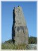 Lista har en rekke historiske steder det er verdt å besøke. Tar man turen om Vere mot Stavestø og sjøen, kommer man Lista har en rekke historiske steder det er verdt å besøke. Tar man turen om Vere mot Stavestø og sjøen, kommer man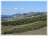 til et
åpent leplantefelt. Mellom dyrket mark og utmark strekker det seg gamle steingjerder, som er lagt opp i bronsealderen. til et
åpent leplantefelt. Mellom dyrket mark og utmark strekker det seg gamle steingjerder, som er lagt opp i bronsealderen.
Langs strandvollen går det en tidligere ferdselsåre. Veien leder mot skogholtet og videre innover skogen, formet som en hulesti. Denne stien som århundres tråkk har preget inn i landskapet, fører til Sausebakk med gamle gravhauger og kultplass. Midt på plassen står en bauta, på folkemunne kalt Vanen.
Gudene Frøy, Frøya og Njord i den gamle åsatroen var vaner og rådde over jord og hav, over fruktbarhet og godt sjøvær. Stedet er tilgjengelig hele året.
På tur i Farsund
Det finnes ca. 3 mil merkede turstier i Farsund, både langs kysten og i mer kupert turterreng. Farsund har 30 km strandsone, hvorav ca. 10
km utgjør fine sandstrender med sanddynelandskap. I Ravneheia finnes det flere fine turområder. Fra toppen av Storefjell har man utsikt over hele Lista.
Løypa rundt Kråkenesvann er omtrent 5 km lang, og går forbi kjente historiske steder som gravhaugene på Lunde og Huseby Kongsgård.
Langs Listafjorden nord-vest på Listahalvøya ligger Varnes turområde. Stier fører frem til Varnes fyr og Varnes fort med kanonstillinger fra siste verdenskrig.
På Øyna kan man følge idyllisk gammel kjerrevei gjennom kraftig granskog og åpent slettelandskap. På gårdene Øyna og Bjørnestad har folk
bodd siden 1600-tallet og levd av gårdsdrift og laksefiske.
Vei fra Hoskuldsnes til Nørskår er relativt bratt med nydelig utsikt på toppen. Gammel kjerrevei går forbi nedlagte Hoskuldsnes skole, idag
privat feriested. Området er nå naturreservat.
Stien over Kirkeskaret mellom Loshavn og Lomsesanden ble i gamle dager brukt av innbyggerne i Loshavn. Turen gir nydelig utsikt over
havet, og steingjerder langs stien markerer teigene som ble brukt til dyrking.
Utvikling og Kulturhistorie
Betydningen av Farsund og Lista som historiske bosettingsplasser bekreftes ved jevnlige funn i området. Spor etter tidligere bosettinger forekommer både i sjøen langs kysten og i jorda innenfor.
I forbindelse med byggingen av aluminiumsverket ble et av de største steinalderfelt som er funnet på Sørlandet, avdekket. En rekke
helleristninger forteller om en rik bosetting frem mot historisk tid, og er understøttet av mange gravfunn.
Under etableringen av Bredero og A-CMI i Lundevågen, ble det foretatt omfattende utgravinger. Disse avdekket blant annet gamle
bosettingsplasser og deler av redskap. Farsund kan forøvrig vise til en av de største arkeologiske samlinger i Vest- Agder fylke.
Kulturlandskap på Lista
De mest karakteristiske trekkene ved jordbrukslandskapet på Lista er alle steingjerdene og rydningsrøysene. Antall, størrelse og tetthet
forteller om hvilket slit det har vært å rydde jorda. Som fylkets største jordbrukskommune, drives det fremdeles utstrakt virksomhet innen landbruk.
Lyngheia utgjør fortsatt deler av Lista-landskapet, men er i ferd med å forsvinne. Røsslyng og andre lyng- og gressarter dominerte tidligere
som et resultat av menneskets påvirkning gjennom tusener av år. Da jordbruket begynte for ca. 6.000 år siden, var disse heiene dekket av
løv- og furuskog. For å skaffe beite til husdyra ble skogen hogd eller brent. Regelmessig sviing holdt trær og lyng nede slik at gresset fikk komme frem.
 Listabøndene har i flere tusen år drevet med sviing av beiteområdene på heia. På Lista finnes det fremdele Listabøndene har i flere tusen år drevet med sviing av beiteområdene på heia. På Lista finnes det fremdele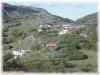 s saueeiere som
svir lyng og kultiverer beitene på den gamle måten, bl.a. på områdene mellom Jølle og Rudjord. s saueeiere som
svir lyng og kultiverer beitene på den gamle måten, bl.a. på områdene mellom Jølle og Rudjord.
Rundturforslag
Tonstad - Kjerag - Lysebotn
En heldagstur i en imponerende natur, enten man velger en 2 timers fottur inn til Kjerag, eller å kjøre ned til de 27 hårnåssvingene til Lysebotn, og tar båten til Stavanger.
Kjør RV 466 og RV 42 til Tonstad, RV 468 til Øvre Sirdal og ned til Lysebotn. Fra Stavanger kan en velge enten E-18 eller RV 44 (Nordsjøveien) tilbake til Flekkefjord.
Dyre- og Fritidsparken i Kristiansand
Turen til Kristiansand tar ca. 1,5 timer, og parkens opplevelse- og aktivitetstilbud er verdt å bruke en hel dag på.
Lindesnes
Norges sydligste fastlandspunkt. Lindesnes fyr er landets eldste. Restaurant og galleri på området. Kjør RV43 til Lyngdal og deretter
Nordsjøveien til Spangreid og Lindesnes. Tilbake kan en kjøre RV 460 til Vigeland og E18/RV43 til Farsund.
Knaben
Knaben var et gruvesamfunn bygget på funn av Molybden. Knaben Grubeselskap ble nedlagt i 1973. Fint område for turgåing og rekreasjon
sommer og vinter. Kjør E18 eller RV 465 over Listeid til Kvinesdal. Følg deretter RV 465 til Knaben. Beregn ca. 2,5 timers kjøretid.
Jøssingfjord - Egersund
Kjør E18 til Flekkefjord og Nordsjøveien (RV 44) mot Egersund. Her vil du passere Jøssingfjord der det tyske skipet Altmark ble senket. I
Egersund anbefales et besøk på Fayancemuseet. Fra Egersund kan du kjøre E18 til Kvinesdal, deretter ta RV465 over Listeid tilbake til Farsund.
|

